Monday, July 30, 2012

Boulder to SouthPass 7/28 62 miles


We had a good stay at a rv park in Boulder.  Lots of laundry done, and they had a huge grass field where we played lots of frisbee golf with Silas.  We got out early again this morning knowing that we were going to have hot, open, country to ride.  The first 20 miles were paved, crossing the trails blazed by J.C. Fremont and the Kit Carson.  The next 25 were on some of the smoothest dirt roads we've ever been on.
 We criss-crossed the Oregon Trail many times.  The state of Wyoming has marked every crossing with a pillar.  You can even see remnants of their wagon wheel tracks through the sage brush lined hills.  After 45 miles, the long ribbon of smooth dirt became 17 miles of sandy, washboard.  We were in the wide open, sun-soaked range and hating it.  Every roller coaster seemed to get higher, and extend farther into the never ending distance.  One final washboard hill to the highway, then down to a shaded rest area where we waited for Sarah and Silas to show.  While we were waiting, six buses from Utah pulled in, unloading over 400 Mormons who just finished a re-enactment of a crossing made by Mormons settlers to the west, in which 75 of the 400 died.  Two of the travelers sat down and talked to us about their re-enactment, while waiting for their bus drivers to take a break.  They were also very interested in our travels.  Minutes later, Sarah appeared.  From there we decided to skip the next section of 137 miles of dry, wide open country, because of time constraints.  We figured since we have to skip some sections anyway, that we should skip these.  We drove about 2 hrs to Rawlins, a rundown old coal town traversed by the Mormon Trail, the Oregon Trail and the Overland Trail.


We found a forest service camp just out of town on the Teton Reservoir.  This was just a pond, but a flock of pelicans lived there, and sandy hills leading down to the water, filled with red ants(Silas discovered to his absolute horror)!  We sat in the comfort of Rocky while a tremendous thunder and lightning storm passed over us.  We played Sequence hoping to take our minds off the great cataclysm occurring  outside.


More pics here

Whiskey Creek to Boulder 7/27 36 miles


We gave Daren the day off, and headed out under cloudy skies to Boulder.  We actually rode as far as Pinedale, then skipped the last 12 miles to Boulder because it was pouring rain and we had met Silas and Daren for lunch and lost our ambition.
We rode on open highway for 24 miles.  We had a tailwind and huge rolling hills.  It was all we could do to keep Silas in sight on these wide open hills.  He loved the thrill of the downhills, and the ability to out ride us on the hills.  Daren passed us on this same open highway just as pronghorns were racing away in the fields.  Silas gladly climbed into Rocky at Cora's Post office.  Sarah and I continued to Pinedale at a little more leisurely pace, excited about lunch.


A few more pics here

Dubois to Whiskey Creek Camp 7/26 48 miles


Another beautiful cool morning to start immediately on a 10 mile
climb to 9600ft, my highest climb so far.  It took 3hrs of steady climbing to go those 10 miles.  Grueling, loose gravel, beautiful!  Behind us the Bridger Mtn's., once over the top, the Tetons in front of us.


 We met a Dept of Agric. land manager at the top.  We talked with him for about half an hour about the fires in the south, grazing rights of permit holders and how he makes sure they're not overgrazing the land, and how he would not recommend tent camping here "cuz of them grizzlies".


Then we started riding through the subalpine wilderness towards Whiskey Creek.  The road was very rough and we had to stop a few times to take a break from the pounding.  We spent the night dry camping on the beautiful raging Green River.


More pics here

Moran to Dubois 7/25 50 miles


Grand Teton RV Park (6miles from Moran Jct) TO Dubois, WY
Daren & Sarah riding

We had a chilly start to what was supposed to be a difficult 50 miler cresting the highest pass yet on the trip, Togwotee Pass at 9,658 ft.  We had options to get off the highway and onto dirt, but the shoulder was so wide and the traffic so sparse that we elected to just stay on the road.  It's amazing what a difference climbing on asphalt makes!  


We were stopped by road construction at what we guess to be a more difficult stretch of climbing.  We weren't allowed to ride our bikes, we *had* to put them into one of the road crew's pick up truck and be driven over 3.5 miles of dusty, dirty, highway revisions.  When we were deposited at the other side, we felt as if we had cheated our way through this supposedly horrendous climb.  We continued on smooth pavement, up and up, but it was so gradual that after cresting a hill and beginning a descent that didn't seem to end, we had to stop and check the GPS to see if we had, in fact, finished the pass without even noticing.  We had!  And we felt terrible about it.  ;)  The next 20 miles (it seemed) was a screaming downhill on beautiful wide shoulders that didn't require any use of brakes for cautious riding.  When we reached the Wind River basin we had some long flats and slight rolling hills to contend with, but again, riding on pavement allowed us to keep a swift pace.

We stopped at the Tie Hacks monument-- these were specialist loggers who were able to fell the perfect sized tree for railroad ties, strip it of it's limbs, and send it to the river for use as railways expanded in this part of the U.S.   At this same memorial we learned where the name of our favorite bike/apparel shop in Jackson Hole, "Hoback's" came from.  There is a 'Hoback Junction' along this route, also a Hoback River, named for… well, we didn't get that part of the story but we're glad to know "Ho-back" isn't just what you say when Jody's riding behind you… (tee hee).

A few more pics here

Jackson, Wy to Moran 52 miles 7/24


After what seemed like a very long break from riding, 3 days, we're back on the trail.  This morning Silas is riding with us from Jackson to Moose, Wy. Since we drove south of our designated route to Jackson, we wanted to backtrack to get back on it.  This route goes past the incredibly rugged and beautiful Tetons.
 The morning started out overcast and drizzly, our kind of weather!  The first 3 miles were on a major highway with lots of traffic to keep you nervous.  We passed a large warning sign of moose on the highway next mile.  Of course we didn't see any moose :(
After 3 miles, we were able to ride on a great bicycle/running path.  It took us past beautiful ranch land, and the Jackson Hole Ski Resort.  Silas and I saw what we thought was yard art of a mule deer on someone's lawn, but the art turned it's head which gave us quite a start!  Live yard art, and we were only 20 ft from it!  We entered Teton National Forest, all dirt roads, very hilly, with lots of ponds that supposedly moose are seen in all the time, but not today.  I know I'm supposed to be happy about not seeing moose close up, because they can kill you, but  I would be happy to see one from a distance sometime!
After 20 miles of great riding with Silas, he can climb faster than I can, we left him with Sarah rv at Moose, Wy.  Daren and I continued on to Moran, which borders Yellowstone. another 32 miles.  We rode on another brand new bike bath past the Tetons and into the Teton Wilderness.  The path we found out, was funded by the family of a 12 year old girl who was killed while riding on the highway.  A very sad situation.  The trail certainly relieves a lot of worry for anyone riding it.


More pics herehttps://plus.google.com/photos/112714069817620713891/albums/5769981776425954321?authkey=CPPM79iOoZmK6AE

Friday, July 27, 2012

Yellowstone to Jackson Wyoming 7/21-7/23


We decided to take a vacation from our vacation and spend two days in Yellowstone, and one in Jackson.  We left Red Rocks rv park in Idaho early, hoping to spot the family of moose everyone seemed to be able to see just from the road.  I think I'm cursed, because we couldn't see them.  I have yet to see a moose or bear.
We entered Yellowstone through the West entrance and drove what is called the Grand Loop.  Along the way, we saw beautiful waterfalls, and young trees regenerating after a devastating forest fire that occurred in 1988.  Along the treed landscape we saw steam rising up in many places.  The land in this region is part of a huge volcano.  The central part of the park collapsed, forming a 30-45 mile caldera that is filled with geysers, mud pots, hot springs, and fumaroles(steam vents).  We were constantly amazed by the varied landscape.  At Mammoth Hot Springs visitor center, we saw a movie on the origins of Yellowstone.  It was a peaceful movie about the many geologic wonders and the incredible wildlife within.  We were mesmerized, and then horrified when they showed a home video of a young visitor and her family outside their car approaching a bison for a close up picture.  Next thing you know, the bison gores the little girl and flips her several times.  Everyone in the audience gasped.  We left the theatre in horrified silence!
 The wildlife was numerous, including herds of elk, bison, and black bears.  The only time there was congestion from cars and other motorhomes, was when wildlife was spotted.  Even though you're not supposed to stop or slow down, everyone does, to see what's going on.  There were at least 40 cars stopped observing a mother and two cub black bears.  The  rangers were somehow notified and had to get people moving.  I tried to take a drive by photo of one of the cubs, but managed to only get an obstructed view of it, pathetic!  Minutes later, we saw a bison.  Several people were trying to get a close up photo.  Obviously, they had not seen the movie!
 The canyon surrounding the Yellowstone River was very dramatic, with incredible rock features and waterfalls.
On the way to our campsite at Bridge Bay, we stopped at the Fishing Bridge on Lake Yellowstone.  This bridge was built in the early 1900's to fish from, but soon fishing was halted from here because it was found that native Cutthroat trout which were becoming extinct, were spawning here.
Daren spent the evening at the campground fixing our bike rack.  It was getting very loose and creaking badly.  It turns out a bolt sheared off.  Probably from driving over so many washboard roads and then hitting speed bumps too hard.  Sarah went to the amphitheater at the park and listened to a Ranger Patrick talk about bison.
The next morning we headed for Old Faithful.  Because Old Faithful is very predictable, there were times posted for eruption times, give or take ten minutes.  There were benches surrounding the geyser area, filled to capacity when it was close to the time.  Remarkably, just before the eruption, a bison entered the arena stage right.  The crowd was awestruck.  What to do, what to do?  Pics of the eruption, but the bison.  Fortunately, the eruption occurred and the bison stayed well after.  Everyone could get shots of both!  Unbeknownst to us all, two more bison entered an area behind the ring of seats.  As people were exiting the geyser area, one of the bison became very agitated and started charging people on a boardwalk leaving the area.  Rangers  rushed in trying to get people back and away.  Daren and Silas were on that boardwalk, somehow oblivious to the scene unfolding, and then at the last second realized.  Fortunately, no one was hurt, and the bison left the area.
After that fun, we decided to drive up the road to the Grand Prismatic Spring area and then leave the park and head to Jackson.  We were amazed at this area.  It seemed like something that would be on mars.  The vibrant colors, geysers within the springs, just amazing.


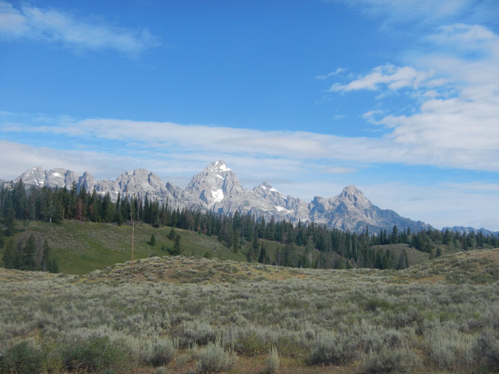
By mid afternoon we headed out of the park through the south entrance, heading for Jackson, Wyoming.  The rain was pouring for most of the drive, somewhat obscuring the view of the Tetons.  By the time we hit Jackson, the rain had stopped.  After setting up camp, we walked to Bubba's BBQ.  Some of the best ribs ever, and buttermilk pie, a first, and delicious.


The next day we all rode our bikes downtown, first to the post office, where Daren had to send a package home of "unnecessary" items.  Then we had a great lunch in town.  After, Daren and Silas went for a bike ride, I went for a haircut, and Sarah went looking around town for interesting shops.  We were pretty antsy to ride again, and got busy getting provisions and getting ready to hit the rode early the next morning.

More pics of Yellowstone and Jackson here, and here, and here


Wednesday, July 25, 2012

Red Rocks Wildlife Refuge to Red Rocks Rv-Idaho 7/20 20 miles


After a very restless night, we woke to rain pounding the tent at 4 am.  Oh no!  Well, at least it's not 90 degrees!  By the time we got out of our tent at 6, the rain had stopped.  We were able to enjoy our oatmeal and some fantastic coffee from Deby and Donn.  We needed that after little sleep.  We had noticed the night before that a pair of cyclists had come into camp.  We did not get a chance to talk to them then, but this morning we met the father of the father and son cycling duo.  He was a man of say 70, very fit and strangely, caring a large chefs knife.  We joked with him about the need to walk around with such a big knife.  He didn't really give an explanation, so we changed the subject.  He and his son of 23 were riding the Divide.  They were only going from Idaho Falls then to Colorado.  He had ridden other segments at other times.
We left by 6:30, under threat of rain, on another loose gravel road.  As we made our way towards Red Rock Pass, we saw several antelope crossing the road.  The pass was short and steep with only 25 yards of walking, then our 6th Divide crossing into Idaho.  The descent to Red Rocks Rv was fun and uneventful.  Beautiful country, and apparently a moose family lives right down the road.  We decided to try to look for them the next morning on our way to Yellowstone.
Our priority this morning was showers, laundry and drying out our wet camping gear.
The next three days we're going to take a short break and spend it in Yellowstone, then Jackson Hole Wyoming.


More pics here


Lima to RedRocks Lakes National Wildlife Refuge 7/19 58 miles


We are excited to leave Lima and head out on our first overnight.  We got a very early start because we knew the sun was going to beat down on us all day.  The first 10 miles were gradual with easy dirt roads and climbing.  The next 38, some of the worst roads we've been on.  After yesterdays ride, I was, how should I say, emotional, and had to stop every five to ten miles just to regroup and gather good thoughts.  There was a lot of loose rock, sandy throw you off your bike stretches, and washboard.  You get the picture.  The scenery was wide open pastures and sagebrush.  Beautiful country, and we were trying very hard to appreciate it!  We saw several thousand cows(slight exaggeration) and cowboys herding them to different fields.  We even got to chat with an older husband and wife on horseback who were rounding up a stray cow.
Eventually we got closer to the Centennial Mountain range that we had been seeing in the distance the whole ride.  And our dreams of smother roads came on the last ten miles as we made our way through Lakeview, where the offices for the wildlife sanctuary we were heading to were located.


Finally, we made it to Red Rocks.  A beautiful refuge of 32,000 acres, set up in 1935 as a breeding ground for wild birds and animals the trumpeter swan being their main focus.  We had to wear DEET because of the man-eating mosquitos.  There was a gushing fresh water spring that replenished our water supply with.
We were so tired after two hard days that we were ready for bed by 6.  It was just too hot to crawl into the tent, so we braved the bugs and fell asleep in one of the only shady spots we could find.  Providing the shade was a small tree that had a robin's nest in it.  For the 3 hours we spent under that tree, we observed, when we happened to be awake, the mama and papa robin feeding their three babies.  Mouthfuls of grasshoppers and various bugs were constantly before delivered to there hungry mouths.  It was like watching a nature channel on tv.


While getting ready for a fabulous freeze dried dinner of shepards pie and beef stroganoff, a couple pulled into camp on BMW dirt bikes.  After a while we introduced ourselves.  We found that they were from the Seattle area(Preston), and were doing a modified Great Divide ride among other routes, ending in Colorado where they were meeting up with fellow riders(Harley's though).  We really enjoyed talking to Deby and Donn.
They were even so kind as to offer bug repellant wipes, whiskey, wine, all those basic needs!  We took them up on the wipes and headed off to our tent.  While laying there sweating to death in the hot tent, we noticed the sound of what seemed like distant chain saws.  Come to find out, it was the sound of a gazillion mosquitos in a tornado like spiral above the camp.  Deby and Donn told us the next morning that they were trying to find the source of the sound and saw this above the camp!


For more pics click here


Bannack to Lima 7/18 58 miles


Well, after a great camp in Bannack(so much history), we headed out to Lima.  This ride goes down as one of the worst so far.
It started out innocent enough, riding through huge swaths of range land with the Beaverhead Mountains to our right.  We ticked off 25 miles with little effort.  Then the wind started to pick up.  Those endless miles that we could see before us, stopped going by so fast.  We tried to keep our heads down as much as possible, hoping that if we just peddled harder we would be done.  But the wind was really howling.  We found ourselves pedaling hard downhill just to go 6 miles an hour.  NOT FAIR!  Side gusts  practically knocked me off my bike.  Daren turned his back slightly to try to become a sail!  Our water was getting low, the heat was on, and pumping water in very questionable pasture land did not seem like a good idea.  With the fear of running out of water, and 33 miles to go, we slowly made our way.
We had a nice diversion, when two horses decided to run with us along a quarter mile stretch.  They were so beautiful, and of course undaunted by gusts.  They came to a fence, and then a herd of cows had to cross in front of us.
As we started up into the Medicine Lodge Sheep Backcountry, we met two motorcyclists traveling the Divide route in reverse.  So far this trip we have met up with at least 8 motorcyclists doing the route.  Most are riding BMW dirt bikes, well loaded, ready for the long haul.  We were slightly envious of their mode of travel on this stretch, but couldn't expend too much energy dreaming about what was not going to happen.  At least now the scenery was changing.  We made our way into a canyon of beautiful  rock faces and out croppings.  The Big Sheep Creek flowing next to us.  At this point we noticed that the wind was shifting, and we had the most glorious tail wind, YEAH!  The final ten miles were almost delightful.  We could see fish in the creek to our right, lush pasture land before us, beautiful canyon walls starting to surround us.
We ended in Lima(not a highlight), way worse for wear.  Sarah said the RV park owner hears comments from other cyclists that this area is the worst of the ride.  At least we weren't the only ones!


More pics here


Tuesday, July 24, 2012

Little Joe Campground to Bannack State Park 7/17 38 miles


For more pics click here


After a rainy stormy night we woke to a beautiful sunny morning.  Silas started the morning with Jody and I and got his first taste of real climbing as we worked our way up 1000 feet over the first 8 miles.  He had reached his limits and was giving us the business when a huge heard of cattle was driven out of the woods directly in front of us by 10-20 horseback riders and dogs.  It was an impressive site and made things interesting as we tried to dodge the land mines they left on the highway. We reached the top of the climb a short time later and started a long steep descent at speeds up to 36 mph that left Silas grinning and his parents terrified for his life.  We met up with Sarah for lunch a few miles later at Polaris,  and Silas abandoned us for the comfort of the RV.

 The rest of the ride to Bannack State Park was hot, rolling and uneventful other than meeting up with a retired woman, Sue,  from Germany who was riding around the country by herself.  She had done a lot of riding in the past and had the best touring set up I have ever seen including front/rear panniers, a bear proof food storage cannister, handlebar mounted Computer and GPS, a solar recharging panel and a top of the line bike with an internally geared hub.  Best of all, everything was black, gray or white and matched perfectly.

After talking and riding with her a short distance we turned south towards our days final destination of Bannack State Park which turned out to be one of the highlights of the trip so far.  As we rode into the park, we passed an old cemetery that was overgrown with sagebrush and looked like something out of an old western.  Most of the tombstones were for people that died prior to 1900 and almost all were less than 30 years old. Some of the tombstones had recent decorations including several small brightly colored toys on the grave of a 4 year old that died in the late 1800's.   

Bannack itself is a ghost town that was built around the site of Montana's first gold strike and became the first state capitol . There are about 50 structures that are open to the public including the old jail cell with it's "unobstructed view of the gallows" through the iron bars of the only window.  The jail/gallows were built by the towns sheriff Henry Plummer.  Apparently Sheriff Plummer had a side job as the leader of a gang of road agents that killed over 100 people and were known as the "innocents".  When the locals figured this out, they tracked him down and gave him a "good drop" on the very gallows that he had commissioned.  The next day the vigilante's continued their work by trying to question a resident named Joe Pizanthia.  Joe refused to come out of his cabin and shot the first two men that tried to enter so the crowd got a cannon and shelled the building.  As the story goes, Joe was injured, dragged from the cabin, shot over 100 times and "with the cabin ablaze they threw his body into the flames".   


Monday, July 23, 2012

BeaverDam(Fleecer) to Little Joe Camp 7/16 38 miles


Well, we started the morning a little more anxious than normal about the upcoming ride.  The famous, or as the book says "infamous" Fleecer Ridge was before us.  We started at approximately 6800ft and climbed to 7800ft.  Only 1000ft difference, but it was quite a challenge because of the altitude.  We are getting accustomed to these elevations, but forget any conversation during these climbs.
It was a cool morning which helped.  Beautiful meadows filled with sage and lupine surrounded us.  And then a not so intimidating hill.  We both gave it our best, but found ourselves walking again.  We nearly missed the "turn", which was just a slightly worn track in the grass to a short section of dilapidated fence.  Then the decent.  Again, we couldn't see the big deal, but found ourselves walking zig-zag through the sage to get down the rock strewn steep descent.  The fragrance given off by the sage underfoot was wonderful.  It made it all more bearable.
After a quarter mile, we were back on our bikes flying down a well worn path.  Unfortunately the fun was exchanged for disgust when we couldn't avoid the numerous and trail covering diarrhea patches from a nearby herd of cows!  Our bikes, legs and bags were covered!  Thank goodness there was a stream nearby where we gave everything a bath.
The ride into Wise River was uneventful.  There Silas and Sarah were waiting.  Silas rode with us from this point to Little Joe Campground, a 20 mile hilly road ride through beautiful canyons on the National Scenic Highway.  We came across historic homesteads, and even a dedication to a young settler who came to this country at 13, and made a meager life panning for gold and farming.  We saw the graves of  his family before us.
The entire ride we were under the threat of a big thunderstorm, and spent the last 2 miles racing into the camp getting soaked all the while.  Fortunately, Daren had his trusty tarp, so while we were waiting for Sarah to show after fueling up and getting groceries in Dillon, we were covered.


More pics here


Butte to Beaverdam Camp 7/15 32 miles


More pics here


Sarah here-- writing the blog post for the ride out of Butte where Jody stayed with Silas to spend just a few extra minutes with 'The Cousins'.  I started the day picking on Daren before we even left the campground.  He seems to be adding new bungeed safety item, or 'just-in-case' tool to his bike frame every day.  It's lucky for Jody and me-- because in a pinch we know he'll have just the thing we never even considered bringing but desperately need.  Today I noticed he had what appeared to be a 4 season 3 person tent bungeed to his handlebars, so of course I had to ask why he thought we needed a tent at all.  He assured me that it was just a a TARP, not an entire tent, and that you just never know…


We had about 10 miles of pavement riding before we started a long, gradual ascent to reach Continental Divide Crossing #5.  In all we climbed 1800 feet to get there but it was heavily forested and, for the first time since West Glacier, a chilly ride.  Up at 7300 feet we had great views of the Pioneer Mountains-- lots of sage, lupine, and other wildflowers.  There were also large, beautiful rocks littering the landscape up there.  It will be interesting to get my hands on the geological history of that area, for now-- 'large beautiful rocks' is all I can say.


 We enjoyed 6 miles of rolling hills… for some reason much of the hills up there were made of soft wet sand which isn't easy to ride in, so though beautiful, I was looking forward to having the rolling hills behind me.  When we finally reached what was to be a 4 mile descent-- Daren's rear rack braze-on brazed-off.  BUT, Mr. Safety-First-A-Boy-Scout-Is-Aways-Prepared made a quick fix with zip ties, (and of course had an entire spare rack setup back at the ranch), and we were back in business descending to the highway where Jody would be waiting-- except we were early and she wasn't there yet.  


We sat at the off ramp awaiting pickup.  Daren went straight for his maps, reviewing the ride for tomorrow and beyond, and I descended the slope to a patch of good napping grass.  I was awakened from a nap by Daren alerting me to something "big and ugly" approaching (I thought he was making a joke about the winnebago, since they're still occasionally rejecting the new identity of "RV Owners").  I popped back up to his perch to see what he was seeing.  The first big rain drops started dropping.  Dark storm clouds were obscuring the mountains that were 'just there' a second ago.  We laughed at our predicament as we put on layers and rain shells, but then  Crash--Crack!  Thunder and lightening.  **It was a GOOD thing Daren had that TARP bungee'd to his handlebars because we SURE needed it.**  We quickly grabbed our stuff off the bikes and went to lower ground-- holed up under the tarp, anxiously watching the highway of oncoming traffic until Jody arrived.  Luckily-- we weren't stuck in the storm for too long when Jody showed up, feeling terrible of course for leaving us out to dry-- or soak, rather.  

We hopped into Rocky as quickly as we could and drove through what became a torrential rain storm.  As suddenly as it had started, the bad weather was behind us and we arrived to blue skies and sunshine at Beaverdam Campground.  

Sunday, July 22, 2012

Moose Creek to Basin 7/13 29 miles


More pics here

Another early start today, 6:30.  We of course wanted to beat the heat, but more importantly wanted to get to Butte to see Steve, Tamera, Atle and Aryton.  We decided it would be too tough to ride all the way to Butte so we ended in Basin another run down remnant of a mining town.
We started climbing steeply almost immediately and didn't stop for 15 miles.  Along the way we herded many stubborn cows and passed some beautiful country.  We worked our way up to my least favorite part of any ride so far, the 4 mile 4-wheel drive destroyed segment.  We easily walked 3.5 of the 4 miles.  I fell for the first time( I know, shocking) and lots of expletives were heard by the rabbits and chipmunks.  Eventually we made it out to a beautiful canyon with rushing creeks, old mine remnants and incredible rock walls.  Basin had many historic buildings but little else.  Again, a welcome site to see "Rocky" waiting to take us to Butte.
Butte pics here

Butte was great!  We walked to "Uptown" where we had a great dinner at the Uptown Cafe, then walked a few short blocks to Kevin, Amy and Calvin's house, where Steve and Tamera were staying.  Kevin and Amy are old friends of Steve and Tamera's, and who we have spent many wonderful trips to Bitteroot with.  We had a very enjoyable evening with them all, and even had time to walk down to the folk festival that was kicking off that evening.  We listened to Congolese music and a bit of Zydeco, then headed home.
The next day we spent at the folk festival and then had a great dinner at Kevin and Amy's.  Daren opted out, and went in search of bike shops to supplement our stock and nap.  Sarah spent most of the day working on job apps and then heading to folk festival.

Friday, July 20, 2012


7/12/12 - Marysville to Moose Creek

For more pics click here

After the day off we were up early to avoid the heat.  Jody dropped Sarah and I at Marysville where we had to regain 1000 feet over 2 miles while dodging mining trucks and washboards to get back to the "official" route.   Although the road was relatively good, it was steep enough that it warranted some pushing (and a little swearing).

After passing a couple of working mines we regained the route at continental divide crossing number 2 (6400 feet).  The next 10 miles or so were mostly downhill through hillsides that were littered with clear cuts, slash piles and the remains of old mines yet still managed to be beautiful in their own way.

After the downhill run the terrain opened up and we began an easy climb towards Priest Pass and the 3rd crossing of the continental divide. As we climbed, we passed a lone cowboy on the hillside above us driving a small heard of cows through the sagebrush.  After topping out at 5994 feet we enjoyed a steep 5 mile decent down to the highway.  

The last 4 miles involved a hot/miserable slog on a wide dusty washboard rode which was uneventful except that we saw our first moose crossing a stream one mile before arriving at our camp site at "Moose Creek Campground" (go figure).  Jody and Silas were waiting for us with ice water, snacks and the rest of our RV comforts.